The MapPolygon type displays a polygon on a Map. 更多...
| import 语句: | import QtLocation 6.5 |
| Since: | QtLocation 5.5 |
The MapPolygon type displays a polygon on a Map, specified in terms of an ordered list of coordinates . For best appearance and results, polygons should be simple (not self-intersecting).
The coordinates on the path cannot be directly changed after being added to the Polygon. Instead, copy the path into a var, modify the copy and reassign the copy back to the path .
var path = mapPolygon.path;
path[0].latitude = 5;
mapPolygon.path = path;
Coordinates can also be added and removed at any time using the addCoordinate and removeCoordinate 方法。
For drawing rectangles with "straight" edges (same latitude across one edge, same latitude across the other), the MapRectangle type provides a simpler, two-point API.
By default, the polygon is displayed as a 1 pixel black border with no fill. To change its appearance, use the color , border.color and border.width 特性。
注意: Since MapPolygons are geographic items, dragging a MapPolygon (through the use of MouseArea or PointHandler ) causes its vertices to be recalculated in the geographic coordinate space. The edges retain the same geographic lengths (latitude and longitude differences between the vertices), but they remain straight. Apparent stretching of the item occurs when dragged to a different latitude.
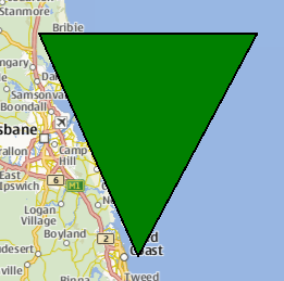
The following snippet shows a MapPolygon being used to display a triangle, with three vertices near Brisbane, Australia. The triangle is filled in green, with a 1 pixel black border.
Map {
    MapPolygon {
        color: 'green'
        path: [
            { latitude: -27, longitude: 153.0 },
            { latitude: -27, longitude: 154.1 },
            { latitude: -28, longitude: 153.5 }
        ]
    }
}
|
autoFadeIn : bool |
This property holds whether the item automatically fades in when zooming into the map starting from very low zoom levels. By default this is
true
。把此特性设为
false
causes the map item to always have the opacity specified with the
QtQuick::Item::opacity
property, which is 1.0 by default.
|
边框组 |
|---|
|
border.color : color |
|
border.width : int |
This property is part of the border property group. The border property group holds the width and color used to draw the border of the polygon.
The width is in pixels and is independent of the zoom level of the map.
The default values correspond to a black border with a width of 1 pixel. For no line, use a width of 0 or a transparent color.
|
color : color |
This property holds the color used to fill the polygon.
The default value is transparent.
|
path : list < coordinate > |
This property holds the ordered list of coordinates which define the polygon. Having less than 3 different coordinates in the path results in undefined behavior.
另请参阅 addCoordinate and removeCoordinate .
|
void addCoordinate ( coordinate ) |
Adds the specified coordinate to the path.
另请参阅 removeCoordinate and path .
|
void removeCoordinate ( coordinate ) |
移除 coordinate from the path. If there are multiple instances of the same coordinate, the one added last is removed.
若 coordinate is not in the path this method does nothing.
另请参阅 addCoordinate and path .